FarmMap4d
Cattle farmers represent Farm-Map Analytics’ core market segment. Based on intensive consultation with pastoralists, land managers and scientists, the Company’s FarmMap4D product integrates the latest technologies to help improve the profitability and sustainable management of cattle farms.
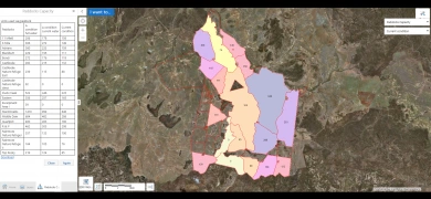
Using geospatial mapping technologies, time-series remote sensing, cloud computing and user-inputted data, FarmMap4D delivers the following highly valued features:
- Access to high resolution satellite imagery
- A user-friendly layered interface to map farm infrastructure, assets, natural features and land types designed for asset management, planning and shareability with various stakeholders
- Time-series ground cover tools to analyse changes in vegetation for any season over the last 30 years in and between paddocks. This has helped inform stocking strategies, benchmarking against neighbouring farms and improvements in land stewardship.
- Carrying capacity analysis tool to monitor and estimate ROI, production efficiency and land condition for each paddock and land type
- Time-series analysis tools to understand spatial and temporal variability.
