Aerial LiDAR
 ACMA Verified

LiDAR-DERIVED ELEVATION & TOPOGRAPHY DATA
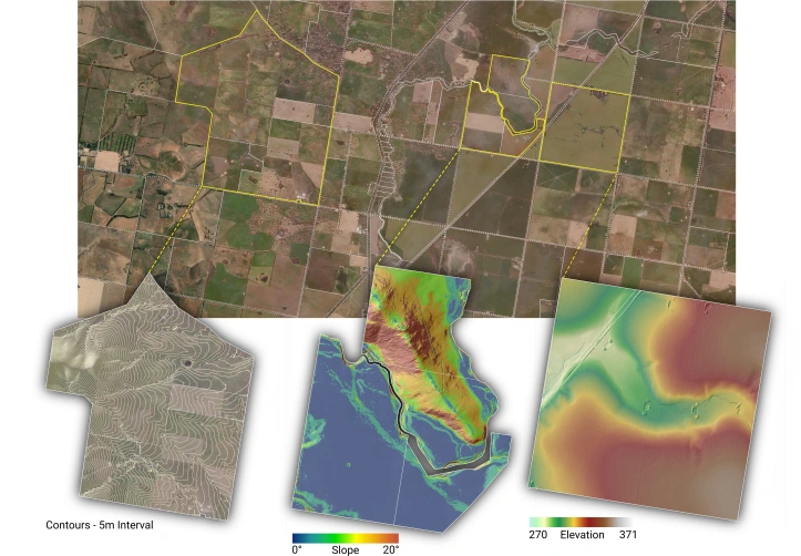
Aerial LiDAR has the ability to penetrate through dense vegetation cover and effectively measure the ground surface below. This makes it the ideal technology to generate datasets that accurately describe the ground surface elevation and topography at a range of scales, from a single paddock to an entire region.
A wide range of elevation and topography datasets can be derived from a single LiDAR survey which can be highly valuable to generate informed land management strategies and support day-to-day operations.
A few examples of use cases include:
- Cartographic contours can be used to generate contour farming designs and help reduce soil loss due to erosion.
- Digital Terrain Models (DTMs) can be used to model how surface water will move across the landscape and help identify potential gully erosion locations. This data can also support development projects designed to increase the residence time of rainwater on a property.
- Highly accurate slope maps can also be used during the development applications by identifying areas that conform to Land Suitability Guidelines (e.g. land <5% slope).
LIDAR-DERIVED VEGETATION INSIGHTS
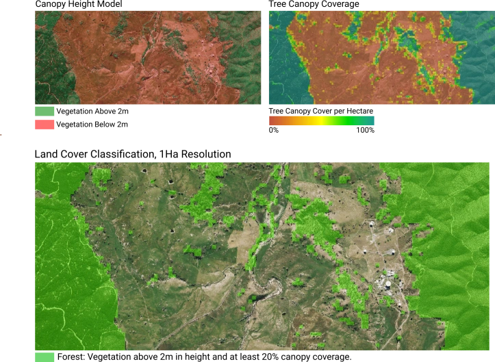
Airborne LiDAR data provides a robust, highly accurate three-dimensional model of vegetation across the landscape.
Datasets can be derived that describe the height, vertical structure, and distribution of vegetation within a property.
Listed below are a few examples of use cases:
- Datasets such as Canopy Height Models (CHM) or Vertical Connectivity Index (VCI) can be used to map habitats for conservation initiatives as well as assist in the identification of areas that have previously been cleared versus untouched native forests.
- Vegetation height and coverage datasets can also be combined to generate landcover maps that are critical for planning carbon credit & offset projects such as human-induced regeneration strategies.
CONCURRENT AERIAL IMAGERY
Aerometrex operates a fleet of LiDAR sensors that all have the ability to collect high-resolution aerial imagery simultaneously with the LiDAR data. Aerial imagery captured alongside LiDAR data typically has a pixel resolution of 7-10 cm, providing an unrivalled visual snapshot of the landscape as it is being flown over.
