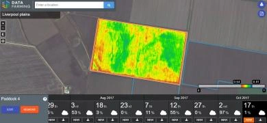
Free real-time satellite imagery
Free access to satellite imagery and normalised difference vegetation index (NDVI), for crop/pasture health, anywhere in the world (every 5 days).
Features:
- Simple registration
- Gain instant free access to 10m satellite and NDVI imagery.
- Instantly target issues and monitor your crop or pasture with imagery updated every 5 days.
- Pin point on-ground issues, dry matter and pasture quality.
- Monitor and track your trials and high value crops.
- Save time and costs knowing where to sample and deliver target solutions like fertiliser or water needs.
- Gain invaluable insight from your imagery and other data.
