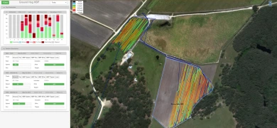
GPS Tracking and Visualisation
Agtrix can provide GPS tracking units for all vehicles (trucks, harvesters, loaders etc) providing vehicle location and sensor data in a single spatial data repository. Agtrix GPS trackers are a technology suited and tested for the agriculture and supply chain environments, balancing simplicity, ruggedness and accuracy.
The key to gaining insights into large scale operational performance and productivity are an understanding of:
Utilisation: When did the vehicle engine start and stop, when did the vehicle first start moving.
Activity: each vehicle’s location, direction, speed, and idling (recorded at 30 second intervals) Agtrix are able to retrieve data from multiple third-party sources, providing the location of vehicles in a fleet with mixed GPS providers in one place.
Visualisation: real time locations from a single map interface in context in real time.
History replay: all vehicle history is available visually via the Agtrix map.
Geofencing: the mapping interface provides the ability for a user to draw geofences for reporting.
Integration with other Agtrix modules provides additional reporting based on fields, loading pads and factory zones.
